
What did we learn so far about the cycling breeding grounds?
1- They have to be flat
2- The climate should be mild
So, after you've climatized your country and moved all mountains, one has to put the country into a shrinking machine to make it truly ideal for cycling.
As a result of the shrinking, all distances become within lilliput range of a lilliput vehicle: the bicycle. Upon shrinking, absolute speed is less important, because everything is nearby anyway. Also, everything gets pushed towards eachother: after shrinking, the density of things becomes higher. E.g., population density.

Can some escape from the Dutch shrinking machine?
Madurodam, The Hague. The puppet population density (puppets/km2) in Madurodam is extremely high.
These apples and oranges are interesting to analyse assuming David is a lobbyist, because in that case he pulled a nice, typical lobbyist trick, making you think that the UK and The Netherlands are not that different in population density. Well, they are quite different. Look at the table yourself.
| Population density (persons/km2) according to Wikipedia | ||||
| United Kingdom | 256 | The Netherlands | 448 | |
| consisting of | consisting of | |||
| Zuid Holland | 1265 | |||
| Noord Holland | 1018 | |||
| Utrecht | 898 | |||
| Limburg | 521 | |||
| Noord Brabant | 502 | |||
| England | 407 | Gelderland | 405 | |
| Overijssel | 342 | |||
| Flevoland | 281 | |||
| Groningen | 250 | |||
| Zeeland | 213 | |||
| Friesland | 194 | |||
| Drente | 185 | |||
| Wales | 148 | |||
| Northern Ireland | 131 | |||
| Scotland | 68 | |||
But what does David say? 'The population density of the countries England and The Netherlands is almost the same.' This is true, these densities are not that different. So, The Netherlands and England are practically the same 'countries'?! Well, they're not of course, because the first is a souvereign state and the second is not. Smart use of semantics. England is a constituting country, not an independent state, effectively similar to a Dutch 'provincie'. Sorry, British, please don't get angry now. England, Scotland, Wales and Ireland being (former) kingdoms is no argument, Friesland was once a kingdom too.
Next, he does compare at the right level, but then he picks his data seemingly after careful selection to make his point: the province Drente is compared to the 'country' Wales, which indeed, do have approximately the same population density as well. In conclusion, David thinks that England is a souvereign state and Wales a province? Don't try to explain that to the Welsh...
As a scientist I decided to provide you with the full data set and then you can make up your own mind. I think that a comparison between UK and NL would be fair: NL population density wins with 175%. Also, England against Zuid/Noord Holland or Utrecht would also be fair: all are the economical engine of the state. The Randstad provinces win with 221-311%. So, The Netherlands are still the most densely populated state in the western world, apart from some city-states like Monaco. No doubt about it.


Population density in The Netherlands 2001. One can clearly see the Randstad (red), the Brabant agglomerations (orange) and the Gelderland agglomerations (yellow) as a continuous very densely populated areas. Dark blue: above540/km2, medium 240-540/km2, light: below 240km2.
Why is this population density of The Netherlands as a state so important? Well, it was the result of some lilliput features, wasn't it? These features are unique for especially De Randstad in The Netherlands, but also e.g., Das Ruhrgebiet in Germany (population density 1117/km2, comparable to Holland). Instead of a single big city surrounded by wide areas of farmland (like in France), it's an entire chain of cities, towns and villages all connected to eachother with some farmland inbetween.
So, the Randstad is not a metropole, because there's quite some green in between, which will turn out to be essential for cycling. If population density in the area would have grown to become a true metropole, cycling would not have been so popular. Actually, this is something David Hembrow also noticed. http://www.aviewfromthecyclepath.com/2011/02/population-density-vs-cycling-rate-for.html Hembrow's graphs clearly show a negative impact of population density inside cities and cycling when comparing internationally....but he doesn't bring the story to completion.
London's growth has actually passed through the very same stage of interconnected villages and towns as the current Randstad, before it became a true metropole. Becoming a metropole killed all cycling possibilites in London (which weren't that many, because London has quite some hills too).
Below, I'll explain why not having a metropole is important for cycling, and how The Dutch actually decided not to develop a true metropole.
No Metropole in Lilliput Country
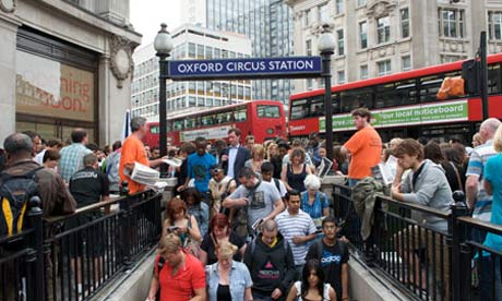
Typical population densities of Metropoles e.g., London (5206/km2), Paris (21423/km2), New York (10.606/km2) are much higher than anywhere in The Netherlands (e.g., Amsterdam 3645/km2, Rotterdam 2850/km2). Only The Hague competes (6117/km2) and still, cycling in The Hague is much more popular than in London (longer distances and hills) or in South Limburg (even higher hills). This is because The Hague is simply much smaller than London: less than 100km2 (10x10km).
In true metropoles, subways, trams, buses and walking are completely taking over the role of the bicycle. Distances between one side of the metropole and the other are much too long to cover with a bicycle: London has a surface of 1577km2, Amsterdam is only 219km2(=11x20km). Amsterdam can be cycled through from one end to the other in an hour or so. London would take you half a day or more. That's why the British invented the Underground... But also in some other aspects, it simply works differently in a metropole.
So, if you dare, you arrive at the London Underground with your bike to go further by subway and then where the f@#$ do you park your bike?
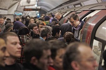
Take it with you into the Underground??? That will make you friends...

Plenty of space to dump your bike in front of a train station in a slightly less densely populated area than a metropole...Delft CS. I'll come back to the role of the Dutch trains in cycling in a later post..
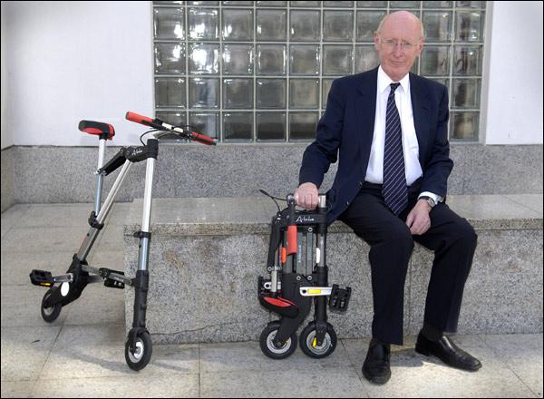
The A-bike, a desparate attempt of a Brit, Sir Clive Sinclair, to fix the problem of cycling in combination with the Underground. The A-bike is an ultra light weight folding bike that can be carried into the Underground. Technically brilliant, but unfortunately, the tiny wheels are neck-breaking, the ultra light weight (6kg) is still too heavy to carry really easily and the ultra lightweight is not robust enough for daily use. I've got it in my boat, just in case. Never used it. http://www.a-bike.co.uk/
Intermezzo - Lillyput Insanity - They want to have it all.
Fact is that The Netherlands went through ~150 years of economical decline of its cities in the 18th century. In that period, the economical power went back to the country side. By the mid 19th century, city growth picked up again, but they remained much smaller than in surrounding countries.
One of the slightly distorted views of the Dutch on their own country is that they still think The Netherlands should play the same leading role in the world like they did in their Golden Age, the 17th century. 'VOC (Dutch East Indies Company) mentality', 'Guiding Country' etc etc pop up every now and then on TV and news papers. Hilarious. In an attempt to manage expectations to a bit more realistic level, a politician once said 'We should start looking at ourselves as the largest of small countries(!) instead of trying to claim a leading role.' Well, that's at least a start.
What does that have to do with cycling? Well, the concequence of our 'VOC Guiding Mentality' is that we want to cram all features a country could possibly have onto a very small surface. As a side effect, everything gets within cycling distance and there are no wastelands in between.
Industrial wastelands: a true cycling killer. Not exactly inviting to cycle through, especially not for women at night. Almost non-existent in The Netherlands, because we'd like to use every square cm of our country. Also, no wastelands means shorter distances.
The Danes at least made a choice (and a good one from historical point of view): farming and Lego, which symbolizes for me all high-end smart Danish design products. Since the mid 19th century, the Dutch just started to do it all. People, farming, industry (mainly high end nowadays), services, nature, trade and logistics (Rotterdam is with 430 million metric tons annually the largest harbor in Europe, making no. 2, Antwerp (180 million), look like a lilliput harbor). All these activities are fighting for a bit of space on our 37354 km2 (less than 200x200km). Anyway, many rich people means many jobs and many activities.
You don't believe me? I'll give one example, farming, because it requires so much space, it historically pressed back the cities already since the 18th century and because it has a nice side effect: it catalyzes cycling.
On 16Million inhabitants, the Dutch have about 12 million pigs, 95 million chicken and 'only' 4 million cows. Whereas the Danes surpass us in number of pigs per inhabitant, they do not in cattle density...

Cattle density in Europe. http://epp.eurostat.ec.europa.eu/statistics_explained/index.php/Cropping_and_livestock_pattern_statistics

International transports through the EU of pigs ready for slaughter. The blue arrow from The Netherlands into Germany seems to yell 'EAT! EAT! EAT! you fat German!'; it's quite insane if you start thinking about it. http://epp.eurostat.ec.europa.eu/statistics_explained/index.php/Pig_farming_statistics
Whether you eat Italian Parma ham or German brat wurst, it's well possible the pig was raised in The Netherlands and only the butchering was done locally. With the same likelyhood, much industrial food in Europe contains eggs or chicken that have gone through the same logistical process.
I think I don't have to elaborate on the Dutch world famous milk and cheese industry. It's not just folklore, but most of all, it's pretty big business, with FrieslandCampina the 2nd largest milke producing cooperation world wide and the 4th milk producing company in Europe.
So what, the Dutch are good with cattle? Well, so we are with potatoes and tomatoes (and anything else in green houses). Also, everybody knows about Dutch flowers.

http://epp.eurostat.ec.europa.eu/statistics_explained/index.php/Agriculture_statistics_at_regional_level
The reason for our insane industrial approach towards farming has its basis in the 18th century, continued in the 19th century to fight endemic famines, and got its final push after WWII due to the 'famine winter' of 1944: Never famine anymore...
This strong economical power of farming actually keeps the Dutch cities and villages separated from each other, preventing them to grow further towards a metropole. Some examples of economically important agricultural regions that protect cycling in the RBG region by preventing cities from becoming a real metropole:
- Het Groene Hart, the 'empty' centre of the Randstad (see figure 2 of this post) is recreational farmland. The choice for het Groene Hart is a deliberate decision of the Dutch government and its planologists from WWII until 2011 to keep the Randstad a nice green place to be.
- Het Westland, 'The Glass City', with all its green houses can be seen in the figure 2 between The Hague and Rotterdam. It produces Dutch tomatoes (famous in Germany) and paprika. Small, but a strong economical power.
- De Bollenstreek This is where all the world famous Dutch bulb flowers are coming from. It's a densely populated area of villages and towns (not even visible in figure 2 as farmland) south west of Amsterdam. Aalsmeer, very much in the Randstad, is the beating heart of world wide flower trade, right next to Schiphol. Buying flowers and fly away is not just done by tourists, it's big agricultural business.
- The economically also very important Dutch pig agro-industry is mainly located in the slightly less densely populated Brabant region (orange cross in 3rd figure) and prevents here the growth of cities.
So, competition between cities and farming on a small surface has delivered a patch work of cities, towns, villages and countryside in The Netherlands, which favors cycling.
Enough about Dutch farming for now. Let's return to our lilliput towns and villages.
Lilliyput towns and villages with lilliput distances inbetween
So actually, our cities, towns and villages aren't very big, roughly between 100 and 200 000 inhabitants or even smaller (apart from the top 5, with Eindhoven 5th), but there are plenty of them on a small surface. This medium size is ideal for middle class decision makers' cycling. Not too big, but big enough and old (narrow streets) enough to cause serious trouble for cars to get in. Big enough also to provide a nice set of shops, restaurants and other entertainment for its inhabitants and the regions around. Big enough and close enough to each other to make The Netherlands the most densely populated country in the western world.
What a difference with the UK, where entire top 20 is larger than Eindhoven. Or Germany, where the entire top 30 is larger than Eindhoven. But the overall population density of these coutnries is still lower...that's due to the horrific emptiness and long distances inbetween those big cities. These distances will kill all attempts to promote relaxed cycling from one city to the other. In the US, this effect is even worse and distances are far beyond a lilliput transportation vehicle like cycling. No cycling distances inside their metropoles nor in between them. Cycling will never become anything serious in the US: too many mountains, extreme climates, too many metropoles and only emptiness inbetween.
The most interesting social geographic thing for cycling in The Netherlands is now to come. In The Netherlands, over 75% of the cycling movements is within 5km. 95% is within 10km. So, somewhere between 5 and 10km, cycling stops to be convenient and people simply switch to cars or public transport. Probably, recreational cycling distances can be a bit longer, let's say 15km.

Dutch cycling movements categorized by distance. CBS 2007.
Now all these Lilliput Dutch towns and cities have satellite villages around them within 7.5 km from the city center. That's an irresistable 15-20min relaxed cycling on flat terrain! So, one can live quietly in a satellite-village and then bike to town to go out shopping, drink a coffee afterwards, visit musea, go for dinner, movies, theatre, party all night and cycle back home in 20min. Also, many recreational/agricultural zones are just a few kilometers further away, holding further city growth. That's how the Dutch middle class decision makers like it!
But it's even not just a single medium size city with some satellites, it's an entire chain of medium size cities and satellite villages in the RBG region, all within 10km from eachother. This Dutch social geographic structure is true cycling paradise!
Maybe one can find a similar structure in a region in your own country, but is it really as inviting to start cycling? Is it as flat, are the distances really that short? Is it really an economically decisive region for the country that can impose cycling at least onto itself but preferably also onto other regions? The Netherlands have these short distances throughout the country, not just in the RBG-region.
Just look at this table as an example that illustrates the Dutch patchwork of cities, satellite villages and country side in its landscape. The patch work model still enables cycling for the 4th largest city of The Netherlands: Utrecht, but not as good as for the smaller cycling student city Leiden. Arnhem is an example in between.
| Town/City | Satellite village | at Km | Recreational country side | at Km | ||
| Leiden | Leiderdorp | 3 | Kagerplassen | 5 | Lakes | |
| 120 000 | Oegstgeest | 4 | Groene Hart | 5 | Agricultural zone | |
| Zoeterwoude Rijndijk | 4 | Panbos | 8 | Dunes | ||
| Warmond | 5 | Beach at Katwijk | 11 | Sea | ||
| Zoeterwoude | 5 | |||||
| Voorschoten | 6 | |||||
| Valkenburg | 6 | |||||
| Rijnsburg | 7 | |||||
| Wassenaar | 9 | |||||
| Arnhem | Elden | 4 | Uiterwaarden Rijn | 5 | Agricultural | |
| 150 000 | Rozendaal | 5 | Veluwe | 5 | Forests | |
| Oosterbeek | 5 | Lathum | 12 | Lakes | ||
| Velp | 6 | |||||
| Westervoort | 7 | |||||
| Utrecht | De Bilt | 5.6 | Maarsseveense plassen | 9 | Lakes | |
| 322 000 | Maarssen | 7.6 | Tienhoven (Loosdrechtse plassen) | 13 | Lakes | |
| Bunnik | 8 | Lekdijk | 14 | Agricultural river landscape | ||
| Nieuwegein | 9 | Lage vuursche | 15 | Forests | ||
| Houten | 10 |

The Dutch patch work model. Cities with satellite villages, industrial zones and agricultural zones. This is textbook social geography. What makes it interesting is the Dutch Lilliput version of it: it all fits within 5-7.5 km for most Dutch cities. Note that the satellite villages are actually even better positioned for the ideal range of a bicycle than cities.
The effect of this social geographic patchwork on cycling
First of all, if you still don't believe me on the hills, then check out the graph below. Even Dutch don't cycle anymore if there are hills: cycling use drops to less than 4x per week (and less than 11% of all movements within 7.5km, http://www.fietsberaad.nl/?repository=Cijfers+over+fietsgebruik+per+gemeente, open the excel file and scroll to the bottom. Around the Vaalsserberg it even drops to 3-4% in the community of Vaals) in the hills of South Limburg (bottom right). I think this is the main conclusion one can draw from the graph.
For now, there is only one other interesting difference: student cities pop up as areas of intense cycling, as explained previously. Other differences are in the details and some of those are weird Dutch quirky things that will be discussed later, but are mostly irrelevant for other countries. Also, some other important effects balance out, so these are invisible on the map.

The total number of cycling movements per person per week. Less than 4 (light): South Limburg: hills. More than 8 (dark): student cities Leiden/Oegstgeest, Ede-Wageningen, Houten/Utrecht, Groningen. Other differences are quirky Dutch things to be discussed later.
http://www.cbs.nl/nl-NL/menu/themas/verkeer-vervoer/publicaties/artikelen/archief/2002/2002-1065-wm.htm
http://www.cbs.nl/nl-NL/menu/themas/verkeer-vervoer/publicaties/artikelen/archief/2002/2002-1065-wm.htm
In conclusion, it appears that detailed differences in population density are not that important for the Dutch situation. Cycling in the RBG area, het Groene Hart, in Amsterdam or the outskirts of Drente and Groningen, it doesn't really matter. Everybody cycles 4-8 times a week. The reason is that those short distances (within 10km) are applicable almost everywhere. The fine patch work of cities and towns with satellite-villages and country side exists throughout the country and works for city people and country men alike. One can just flip their start and finish points: a country man goes shopping down town as easily as city people go cycling to 'enjoy nature'.
Conlusion
So, here comes the conclusion on how social geography supports Dutch cycling:
The Dutch cycle because the distances are short. As these distances are so short, the overall population density of the entire country is very high, but not so dense that it has become a metropole....are you still with me?
As compared to other countries, The Netherlands went through a shrinking machine, starting in the 18th century, which is still actively maintained. The resulting Lilliput country makes cycling actually something usefull that can compete with cars, mopeds and public transport.
So, we cycle in The Netherlands from (macroscopic) social geography perspective because:
- Short distances by a fine patchwork of cities and towns with satellite villages and countryside within 10km distance everywhere.
- No metropoles
- No endless stretches of emptiness
- No wastelands
Hi Magic,
BeantwoordenVerwijderenBig text this time! In my opinion a good piece of work that explains the unique posision the Netherlands have in Europe. (and in the world of course)
The patchwork of cities and villages is indeed not found in other countries, not with the same geografical surcomstances. So You made it clear why it's much easier to take a cycletrip instead of cartransport, and the parkingproblem in the bigger cities makes it even more attractive!
Greetings, Adri.
A fascinating read-- particularly for a velomobile rider originally from New Zealand but now living near London in the UK! It all makes sense and also explains why you see very few bikes outside towns in NZ!
BeantwoordenVerwijderenHi Magic,
BeantwoordenVerwijderenIt's a great read and it can be applied to most cities and countries around the world.
In our part of Canada it is the climate that works against us the most. (no hills here)
Greetings from Canada
Kevin
Thanks guys, this was one of my toughest posts to write. rewarding to read that you liked it.
BeantwoordenVerwijderenWall of text, didnt read...u must be a no-lifer and/or a twisted psycho :-O
BeantwoordenVerwijderenJoking ofc ;-))))
I do think the article is longer (winded) then strictly nessesary since you drag all kinds of information in the article that is not the core of what you are trying to explain. But is is usefull background setting info anyway.
But where Prorail invests millions of euro's in a project to make railroad crossing barriers open a few seconds faster, to prevent stressed people with no patience throwing their lives away in attempt to not have to stop rushing to where ever they need to go, what are the chances of such people reading all of your test ? Or ride a time consuming bycycle ?? ;-))))
Hi Quezzzt,
VerwijderenMagic Bullet made his point absolutly clear, there are of course no garanties at all that people read this post, specially not the kind you mentioned. The kind you mentioned are the no-lifers and\or psycho's as I see it. I never understand what those people are trying to achive, whats the point in rushing form one job to the other? They only ruin their own lives, setting themselves in danger to get heartproblems or other stress-related sicknesses. So Prorail shouldn't invest money for opening railroadcrossings faster, the people you talk about will be stressed anyway, a few seconds faster doesn't help them!
Greetings, Adri.
hi Quezzzt,
BeantwoordenVerwijderenyou knew already I'm a twisted psycho...but I can summarize the blog, no worries. takes the 2nd and last section...less fun to read and no supporting data to make the point. i think. my entire blog is intended for the last of the mohicans that like to take some timeto understand stuff. may be they even read books...
:-)
Deze reactie is verwijderd door de auteur.
BeantwoordenVerwijderenIk kon in m'n reactie geen URL's kwijt. 'k Verwijs daarom naar m'n eigen weblog, wijnandt.blogspot.com , voor een reactie hierop.
BeantwoordenVerwijderenthanks Wijnandt. He points out on his blog that the above described phenomena has of course a name amongst planologists: bundled decontrentration, at least that's what you get upon direct translation. from his post, one can conclude that the Dutch patchwork should be actively maintsined, something I didn't discuss too much in the post above.
BeantwoordenVerwijderenhi Magic, As Easy As Riding responded to your post(s), it's a good read > aseasyasridingabike dot wordpress.com
BeantwoordenVerwijderenThanks Amsterdam, I'll have a look.
BeantwoordenVerwijderen